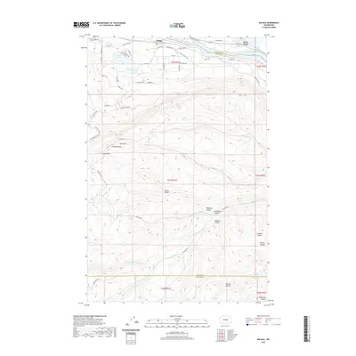
2020 Map of Malaga
USGS Topo · Published 2020About this map
Malaga and Rock Island serve as the primary hubs along the winding course of the Columbia River, here represented by the Rock Island Pool. The landscape transitions from the riverfront residential developments of Lake Cortez and Meadow Lake in the north into a complex network of high ridges and deep drainages to the south. This terrain is defined by the prominent Jumpoff Ridge and a series of steep ravines including Nickles Canyon, Kingsbury Canyon, and Ivy Walker Canyon. The map reveals the seasonal hydrology of the region, where numerous canyons like Dry Gulch and Scroggie Canyon converge toward the river valley, while permanent water sources such as Whitson Spring and Judkins Spring are found at higher elevations. The network of local roads like Malaga Alcoa Hwy and Riviera Blvd illustrates the expansion of settlement between the river and the rising cliffs of Laurel Hill.
Find a feature on this map
62 named features on this map. Tap any name to fly to it.
Don’t see what you’re looking for? This feature index may not catch every label — zoom into the map to look around manually.
Map Details
Editions of this 2020 Malaga Map
This is the sole edition of this map. No revisions or reprints were ever made.
Other maps of this area

1912 · Malaga
USGS Topo · 1:48,000

1913 · Wenatchee
USGS Topo · 1:62,500

1914 · Malaga
USGS Topo · 1:62,500

1915 · Wenatchee
USGS Topo · 1:62,500

1920 · Colockum Pass
USGS Topo · 1:125,000

1922 · Colockum Pass
USGS Topo · 1:125,000

1957 · Wenatchee
USGS Topo · 1:250,000
1966 · Malaga NE
USGS Topo · 1:24,000

1966 · Rock Island
USGS Topo · 1:24,000

1966 · Wenatchee
USGS Topo · 1:24,000