
1912 Map of Malaga
USGS Topo · Published 1954About this map
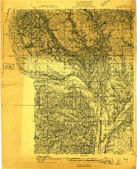
Columbia River topography dominates this 1912 survey, where the water's force is marked by Rock Island Rapids and the engineered presence of the Rock Island Dam. The river corridor serves as the primary artery for transport and settlement, with the Great Northern railroad and the Ellensburg Road threading along the banks and through the canyon floor. High above the river, the plateau is partitioned by an extensive network of school districts, including Columbia Heights School, Liberty School, and the remote School No 83, illustrating the distributed rural population of the era.
Find a feature on this map
44 named features on this map. Tap any name to fly to it.
Don’t see what you’re looking for? This feature index may not catch every label — zoom into the map to look around manually.
Map Details
Editions of this 1912 Malaga Map
2 editions found
Historical Maps of Rock Island Through Time
65 maps found
1912 Malaga
Douglas County, WA

1914 Malaga
Douglas County, WA

1965 Jameson Lake East
Douglas County, WA

1965 Jameson Lake SE
Douglas County, WA

1965 Jameson Lake SW
Douglas County, WA

1965 Jameson Lake West
Douglas County, WA

1965 Mold
Douglas County, WA

1965 St. Andrews
Douglas County, WA

1966 Malaga NE
Douglas County, WA

1966 Palisades
Douglas County, WA

1966 Rattlesnake Springs
Douglas County, WA

1966 Rock Island Dam
Douglas County, WA

1968 Alstown
Douglas County, WA

1968 Barker Canyon
Douglas County, WA

1968 Barnes Butte
Douglas County, WA

1968 Chief Joseph Dam
Douglas County, WA

1968 Coleman Hill
Douglas County, WA

1968 Douglas
Douglas County, WA

1968 Farmer
Douglas County, WA

1968 Foster Coulee
Douglas County, WA

1968 Lamoine
Douglas County, WA

1968 Leahy
Douglas County, WA

1968 Mud Spring
Douglas County, WA

1968 Orondo
Douglas County, WA

1968 Piersol Hills
Douglas County, WA

1968 Sims Corner
Douglas County, WA

1968 Wells Dam
Douglas County, WA

1968 Withrow
Douglas County, WA

1980 Trefry Canyon
Douglas County, WA

1981 Stubblefield Point
Douglas County, WA

1985 Sagebrush Flat
Douglas County, WA

1989 Alameda Flat
Douglas County, WA

1989 Sanderson Creek
Douglas County, WA

2003 Orondo
Douglas County, WA

2023 Alameda Flat
Douglas County, WA

2023 Alstown
Douglas County, WA

2023 Barker Canyon
Douglas County, WA

2023 Barnes Butte
Douglas County, WA

2023 Chief Joseph Dam
Douglas County, WA

2023 Coleman Hill
Douglas County, WA

2023 Douglas
Douglas County, WA

2023 Farmer
Douglas County, WA

2023 Foster Coulee
Douglas County, WA

2023 Jameson Lake East
Douglas County, WA

2023 Jameson Lake SE
Douglas County, WA

2023 Jameson Lake SW
Douglas County, WA

2023 Jameson Lake West
Douglas County, WA

2023 Lamoine
Douglas County, WA

2023 Leahy
Douglas County, WA

2023 Malaga NE
Douglas County, WA

2023 Mold
Douglas County, WA

2023 Mud Spring
Douglas County, WA

2023 Orondo
Douglas County, WA

2023 Palisades
Douglas County, WA

2023 Piersol Hills
Douglas County, WA

2023 Rattlesnake Springs
Douglas County, WA

2023 Rock Island Dam
Douglas County, WA

2023 Sagebrush Flat
Douglas County, WA

2023 Saint Andrews
Douglas County, WA

2023 Sanderson Creek
Douglas County, WA

2023 Sims Corner
Douglas County, WA

2023 Stubblefield Point
Douglas County, WA

2023 Trefry Canyon
Douglas County, WA

2023 Wells Dam
Douglas County, WA

2023 Withrow
Douglas County, WA