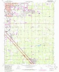
1964 Map of Malaga
USGS Topo · Published 1981About this map
Agricultural irrigation and transit networks define the landscape south of Fresno in the mid-1960s. The map illustrates a complex lattice of water infrastructure, including the Sunnyside Canal, Central Canal, and American Canal, which supported the region's intensive farming. These waterways are interspersed with specialized facilities like the US Experimental Station and the US Dept Agriculture Horticultural Field Station, highlighting the area's role in California's agricultural development.
Find a feature on this map
85 named features on this map. Tap any name to fly to it.
Don’t see what you’re looking for? This feature index may not catch every label — zoom into the map to look around manually.
Map Details
Editions of this 1964 Malaga Map
3 editions found
Other maps of this area

1921 · Bullard
USGS Topo · 1:31,680

1922 · Round Mountain
USGS Topo · 1:31,680

1923 · Malaga
USGS Topo · 1:31,680

1923 · Fresno
USGS Topo · 1:31,680

1923 · Clovis
USGS Topo · 1:31,680

1923 · Sanger
USGS Topo · 1:31,680

1923 · Bullard
USGS Topo · 1:31,680

1924 · Selma
USGS Topo · 1:31,680

1924 · Conejo
USGS Topo · 1:31,680

1925 · Caruthers
USGS Topo · 1:31,680