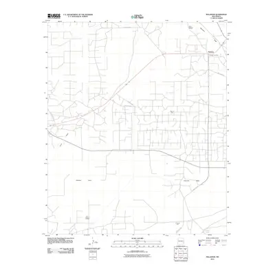
2010 Map of Maljamar
USGS Topo · Published 2010About this map
The settlement of Maljamar serves as the focal point of this Lea County landscape, dominated by the extensive energy infrastructure of the Permian Basin. This 2010 survey details a complex web of service roads and pipelines connecting the North Maljamar Oil Field, Baish Oil Field, and the Young Oil Field to the south. The Maljamar Post Office remains a central landmark within the community, which is situated near the dramatic geological transition of the Mescalero Ridge. Below this escarpment, the Querecho Plains spread across the southwest, interrupted only by ephemeral water features like Taylor Draw and the isolated Little Lake. The map illustrates the specialized road network required for high-density resource extraction, featuring numerous county routes including County RD-252 and the Mescalero Rd that traverse the arid terrain.
Find a feature on this map
16 named features on this map. Tap any name to fly to it.
Don’t see what you’re looking for? This feature index may not catch every label — zoom into the map to look around manually.
Map Details
Editions of this 2010 Maljamar Map
This is the sole edition of this map. No revisions or reprints were ever made.
Other maps of this area

1942 · Clayton Basin
USGS Topo · 1:62,500

1943 · Clayton Basin
USGS Topo · 1:62,500

1954 · Hobbs
USGS Topo · 1:250,000

1958 · Hobbs
USGS Topo · 1:250,000

1962 · Buckeye
USGS Topo · 1:62,500

1963 · Laguna Gatuna
USGS Topo · 1:62,500

1963 · Maljamar
USGS Topo · 1:62,500

1984 · Laguna Gatuna NW
USGS Topo · 1:24,000
1985 · Buckeye NW
USGS Topo · 1:24,000
1985 · Greenwood Lake
USGS Topo · 1:24,000