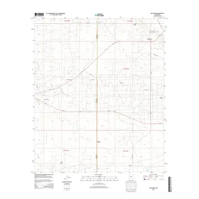
2013 Map of Maljamar
USGS Topo · Published 2013About this map
The high desert landscape of the Llano Estacado is defined here by the sharp relief of Mescalero Ridge, which separates the elevated plains from the lower Querecho Plains to the southwest. At the foot of this escarpment lies the unincorporated settlement of Maljamar, a community deeply tied to the region's energy production. The area is heavily intersected by infrastructure serving the petroleum industry, including the North Maljamar Oil Field and the Baish Oil Field.
Find a feature on this map
30 named features on this map. Tap any name to fly to it.
Don’t see what you’re looking for? This feature index may not catch every label — zoom into the map to look around manually.
Map Details
Editions of this 2013 Maljamar Map
This is the sole edition of this map. No revisions or reprints were ever made.
Other maps of this area

1942 · Clayton Basin
USGS Topo · 1:62,500

1943 · Clayton Basin
USGS Topo · 1:62,500

1954 · Hobbs
USGS Topo · 1:250,000

1958 · Hobbs
USGS Topo · 1:250,000

1962 · Buckeye
USGS Topo · 1:62,500

1963 · Laguna Gatuna
USGS Topo · 1:62,500

1963 · Maljamar
USGS Topo · 1:62,500

1984 · Laguna Gatuna NW
USGS Topo · 1:24,000
1985 · Buckeye NW
USGS Topo · 1:24,000
1985 · Greenwood Lake
USGS Topo · 1:24,000