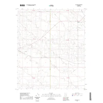
2023 Map of Maljamar
USGS Topo · Published 2023About this map
Maljamar sits at the intersection of industry and the high desert, positioned on the eastern edge of the Eddy and Lea County line. The landscape is defined by the prominent Mescalero Ridge in the northeast and the drainage of Taylor Draw to the west. This modern topographic survey illustrates a complex grid of energy-sector infrastructure, with a dense network of local routes such as Bermuda Rd and Mescalero Rd providing access to the region's oil and gas resources. In the southeastern corner, the small basin of Little Lake serves as a rare hydrological feature in an otherwise arid expanse. The map effectively documents the contemporary balance between the natural geology of the Llano Estacado and the intensive human development required for resource extraction.
Find a feature on this map
23 named features on this map. Tap any name to fly to it.
Don’t see what you’re looking for? This feature index may not catch every label — zoom into the map to look around manually.
Map Details
Editions of this 2023 Maljamar Map
This is the sole edition of this map. No revisions or reprints were ever made.
Other maps of this area

1942 · Clayton Basin
USGS Topo · 1:62,500

1943 · Clayton Basin
USGS Topo · 1:62,500

1954 · Hobbs
USGS Topo · 1:250,000

1958 · Hobbs
USGS Topo · 1:250,000

1962 · Buckeye
USGS Topo · 1:62,500

1963 · Laguna Gatuna
USGS Topo · 1:62,500

1963 · Maljamar
USGS Topo · 1:62,500

1984 · Laguna Gatuna NW
USGS Topo · 1:24,000
1985 · Buckeye NW
USGS Topo · 1:24,000
1985 · Greenwood Lake
USGS Topo · 1:24,000