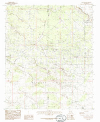
1985 Map of Maljamar
USGS Topo · Published 1985About this map
Mescalero Ridge (the Caprock) forms a sharp geographic boundary in the northeast, separating the elevated Llano Estacado from the lower Querecho Plains. This mid-1980s landscape is defined by its industrial activity, dominated by a pervasive Oil Field that spans the terrain. The settlement of Maljamar sits at the base of the ridge, serving as a focal point for the surrounding petroleum and resource extraction operations, which include several Gravel Pits concentrated in the northern sections. While the terrain is predominantly arid, small water features like Indian Tank and Little Lake are noted on the sheet. The boundary between Eddy Co and Lea Co bisects the quadrangle, illustrating how these two New Mexico counties share the intense energy production infrastructure of the Permian Basin region during this era.
Find a feature on this map
9 named features on this map. Tap any name to fly to it.
Don’t see what you’re looking for? This feature index may not catch every label — zoom into the map to look around manually.
Map Details
Editions of this 1985 Maljamar Map
This is the sole edition of this map. No revisions or reprints were ever made.
Other maps of this area

1942 · Clayton Basin
USGS Topo · 1:62,500

1943 · Clayton Basin
USGS Topo · 1:62,500

1954 · Hobbs
USGS Topo · 1:250,000

1958 · Hobbs
USGS Topo · 1:250,000

1962 · Buckeye
USGS Topo · 1:62,500

1963 · Laguna Gatuna
USGS Topo · 1:62,500

1963 · Maljamar
USGS Topo · 1:62,500

1984 · Laguna Gatuna NW
USGS Topo · 1:24,000
1985 · Buckeye NW
USGS Topo · 1:24,000
1985 · Greenwood Lake
USGS Topo · 1:24,000