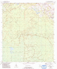
1954 Map of Mallory Swamp NE
USGS Topo · Published 1993About this map
Mallory Swamp dominates this part of Lafayette County, revealing a mid-century landscape of wetlands and timber-related infrastructure. The presence of the Griggs Lookout Tower and multiple stretches of Old Railroad Grade suggests a history tied to forest management and earlier logging efforts. These grades cut linear paths through the natural topography of Brushy Hammock and Wampee Ponds, indicating how the land was navigated before modern road development.
Find a feature on this map
12 named features on this map. Tap any name to fly to it.
Don’t see what you’re looking for? This feature index may not catch every label — zoom into the map to look around manually.
Map Details
Editions of this 1954 Mallory Swamp NE Map
2 editions found
Other maps of this area

1954 · Mallory Swamp NW
USGS Topo · 1:24,000

1954 · Mallory Swamp SW
USGS Topo · 1:24,000

1954 · Mallory Swamp SE
USGS Topo · 1:24,000

1954 · Mallory Swamp NE
USGS Topo · 1:24,000

1954 · Gainesville
USGS Topo · 1:250,000

1954 · Valdosta
USGS Topo · 1:250,000

1955 · Mayo
USGS Topo · 1:24,000

1955 · Mayo SE
USGS Topo · 1:24,000
1956 · Mallory Swamp NW
USGS Topo · 1:25,000

1956 · Mallory Swamp SE
USGS Topo · 1:25,000