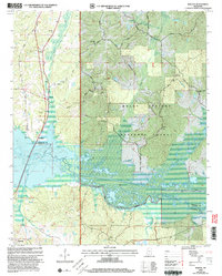
2000 Map of Malone
USGS Topo · Published 2003About this map
The Tallahatchie Experimental Forest and Holly Springs National Forest dominate this north Mississippi landscape, where the Little Tallahatchie River and Tippah River converge into the expansive waters of Little Sardis Lake. This 2000 revision documents a rural environment shaped by the floodplains and levees of the Tallahatchie drainage system. Small settlements like Malone and Spraggins sit along the corridor of Old Highway 7, while Abbeville anchors the southwestern corner near the Graham Creek drainage. The map is a significant resource for those tracing local lineages, featuring numerous historic burial grounds and congregations such as Spring Hill Ch Cem, Greenfield Ch Cem, and Me Maria Ch Cem. Notably, the area hosts specialized scientific and monitoring infrastructure, including the Univ of Mississippi Seismic Station and the Bagley Lookout tower.
Find a feature on this map
50 named features on this map. Tap any name to fly to it.
Don’t see what you’re looking for? This feature index may not catch every label — zoom into the map to look around manually.
Map Details
Editions of this 2000 Malone Map
This is the sole edition of this map. No revisions or reprints were ever made.
Other maps of this area

1940 · Oxford
USGS Topo · 1:62,500

1942 · Denmark
USGS Topo · 1:62,500

1943 · Denmark
USGS Topo · 1:62,500

1943 · Oxford
USGS Topo · 1:62,500

1944 · Tyro
USGS Topo · 1:62,500

1944 · Potts Camp
USGS Topo · 1:62,500

1945 · Potts Camp
USGS Topo · 1:62,500

1956 · Tupelo
USGS Topo · 1:250,000

1958 · Tupelo
USGS Topo · 1:250,000

1964 · Waterford
USGS Topo · 1:24,000