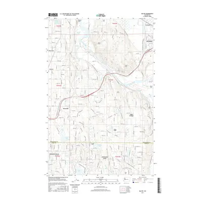
2017 Map of Maltby
USGS Topo · Published 2017About this map
The Snohomish River and Skykomish River converge in the northeast corner of this territory, shaping a landscape defined by floodplains like the Tualco Valley and the prominent Lord Hill. This modern survey reveals the suburban and rural transition between Snohomish County and King County, where established communities like Maltby and Cottage Lake are intersected by a dense network of residential roads. Local history and geography are preserved through numerous water bodies including Crystal Lake, Echo Lake, and the winding Riley Slough. Distinctive landmarks such as Kyles Airport and the high-elevation Mt Forest stand alongside the growing footprints of Monroe and Woodinville, documenting the contemporary state of these long-standing Washington settlements.
Find a feature on this map
110 named features on this map. Tap any name to fly to it.
Don’t see what you’re looking for? This feature index may not catch every label — zoom into the map to look around manually.
Map Details
Editions of this 2017 Maltby Map
This is the sole edition of this map. No revisions or reprints were ever made.
Other maps of this area

1895 · Snohomish
USGS Topo · 1:125,000

1897 · Seattle
USGS Topo · 1:125,000

1921 · Sultan
USGS Topo · 1:125,000

1923 · Sultan
USGS Topo · 1:125,000

1944 · Everett
USGS Topo · 1:62,500

1950 · Redmond
USGS Topo · 1:24,000

1950 · Kirkland
USGS Topo · 1:24,000

1953 · Monroe
USGS Topo · 1:24,000
1953 · Bothell
USGS Topo · 1:24,000
1953 · Maltby
USGS Topo · 1:24,000