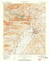
1948 Map of Malvern
USGS Topo · Published 1957About this map
The Ouachita River defines the heart of this landscape, winding past the industry of Jones Mills and the established town of Malvern. Surveyed in the late 1940s, this area shows a mix of industrial extraction and recreation, with a Strip Mine located east of the city while Lake Catherine State Park occupies the northern shoreline of Lake Catherine. The surrounding hills are dotted with rural infrastructure essential to local genealogy, including Sulphur Springs Ch, Antioch Sch, and Spencer Cem.
Find a feature on this map
71 named features on this map. Tap any name to fly to it.
Don’t see what you’re looking for? This feature index may not catch every label — zoom into the map to look around manually.
Map Details
Editions of this 1948 Malvern Map
3 editions found
Other maps of this area

1890 · Benton
USGS Topo · 1:125,000

1890 · Hot Springs
USGS Topo · 1:125,000

1894 · Hot Springs
USGS Topo · 1:125,000

1894 · Benton
USGS Topo · 1:125,000

1938 · Benton
USGS Topo · 1:48,000

1944 · Benton
USGS Topo · 1:62,500

1948 · Malvern
USGS Topo · 1:62,500

1949 · Malvern
USGS Topo · 1:62,500

1955 · Little Rock
USGS Topo · 1:250,000

1956 · Little Rock
USGS Topo · 1:250,000