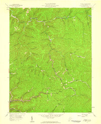
1957 Map of Mammoth
USGS Topo · Published 1959About this map
Mammoth and the surrounding coal-rich hollows of Kanawha County are captured here during a period of intensive industrial activity. The landscape is defined by the extraction of natural resources, with numerous Mines and Strip Mines appearing along the steep ridges and narrow valleys. Transportation for these operations is provided by the New York Central railroad, which follows the winding course of Blue Creek and its many tributaries, connecting small company settlements like Blakeley and Sanderson to wider markets.
Find a feature on this map
73 named features on this map. Tap any name to fly to it.
Don’t see what you’re looking for? This feature index may not catch every label — zoom into the map to look around manually.
Map Details
Editions of this 1957 Mammoth Map
3 editions found
Other maps of this area

1897 · Kanawha Falls
USGS Topo · 1:125,000

1900 · Kanawha Falls
USGS Topo · 1:125,000

1901 · Kanawha Falls
USGS Topo · 1:125,000

1907 · Clendenin
USGS Topo · 1:62,500

1908 · Clay
USGS Topo · 1:48,000

1908 · Fayetteville
USGS Topo · 1:48,000

1908 · Montgomery
USGS Topo · 1:48,000

1909 · Clendenin
USGS Topo · 1:62,500

1910 · Clay
USGS Topo · 1:62,500

1910 · Fayetteville
USGS Topo · 1:62,500