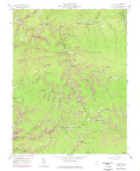
1957 Map of Mammoth
USGS Topo · Published 1977About this map
Extensive strip mining and coal infrastructure dominate the terrain of the Cabin Creek and Elk districts in this 1957 survey, later photorevised in 1976. The industrial footprint is evident through numerous strip mines, conveyor systems, and the Conrail line winding through the narrow valleys of the Blue Creek watershed. This industrial activity is woven into a landscape of small company settlements and hollow-dwelling communities, including Mammoth, Hitop, and Blakeley. Social life is anchored by local institutions like Missionary Ch, Spangler Sch, and various cemeteries tucked away on steep hillsides. Further north, the character shifts slightly towards recreation and rural outposts, evidenced by Camp Carlisle and Camp Galahad along the river loops. The map effectively documents the mid-century density of the West Virginia coalfields before later economic shifts changed the regional population pattern.
Find a feature on this map
85 named features on this map. Tap any name to fly to it.
Don’t see what you’re looking for? This feature index may not catch every label — zoom into the map to look around manually.
Map Details
Editions of this 1957 Mammoth Map
3 editions found
Other maps of this area

1897 · Kanawha Falls
USGS Topo · 1:125,000

1900 · Kanawha Falls
USGS Topo · 1:125,000

1901 · Kanawha Falls
USGS Topo · 1:125,000

1907 · Clendenin
USGS Topo · 1:62,500

1908 · Clay
USGS Topo · 1:48,000

1908 · Fayetteville
USGS Topo · 1:48,000

1908 · Montgomery
USGS Topo · 1:48,000

1909 · Clendenin
USGS Topo · 1:62,500

1910 · Clay
USGS Topo · 1:62,500

1910 · Fayetteville
USGS Topo · 1:62,500