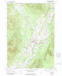
1968 Map of Manchester
USGS Topo · Published 1989About this map
Manchester Center and Manchester Depot serve as the valley’s primary hubs during the late 1960s, situated where the Batten Kill and Bourn Brook converge. This survey documents a landscape of established educational and cultural institutions, including the Burr-Barton Seminary and the Southern Vermont Art Center, set against the backdrop of the Green Mountain range and Equinox Mountain. The valley floor is characterized by its transportation and recreation corridors, with the Vermont Railway following the river and the Ekwanok Country Club occupying central grounds.
Find a feature on this map
73 named features on this map. Tap any name to fly to it.
Don’t see what you’re looking for? This feature index may not catch every label — zoom into the map to look around manually.
Map Details
Editions of this 1968 Manchester Map
4 editions found
Other maps of this area

1893 · Wallingford
USGS Topo · 1:62,500

1894 · Londonderry
USGS Topo · 1:62,500

1894 · Pawlet
USGS Topo · 1:62,500

1894 · Equinox
USGS Topo · 1:62,500

1896 · Equinox
USGS Topo · 1:62,500

1897 · Pawlet
USGS Topo · 1:62,500

1899 · Londonderry
USGS Topo · 1:62,500

1900 · Equinox
USGS Topo · 1:62,500

1903 · Mettawee
USGS Topo · 1:125,000

1950 · Glens Falls
USGS Topo · 1:250,000