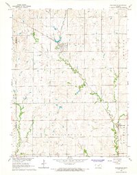
1965 Map of Manchester
USGS Topo · Published 1966About this map
Manchester and Talmage serve as the primary focal points of this mid-1960s survey along the border of Ottawa and Dickinson counties. The landscape is defined by the winding course of Mud Creek, which is paralleled by the prominent tracks of the Atchison Topeka and Santa Fe railroad as it cuts diagonally through the townships of Flora and Willowdale. This map is particularly valuable for genealogists, as it documents several rural burial grounds including White Cloud Cem, Prairedale Cem, and Keystone Cem set amongst the agricultural sections. The drainage patterns of Buckeye Creek in the south further illustrate the local topography of this Kansas prairie region during a period of established rail and river infrastructure.
Find a feature on this map
11 named features on this map. Tap any name to fly to it.
Don’t see what you’re looking for? This feature index may not catch every label — zoom into the map to look around manually.
Map Details
Editions of this 1965 Manchester Map
2 editions found
Other maps of this area

1889 · Abilene
USGS Topo · 1:125,000

1891 · Clay Center
USGS Topo · 1:125,000

1894 · Abilene
USGS Topo · 1:125,000

1955 · Niles
USGS Topo · 1:24,000

1955 · Manhattan
USGS Topo · 1:250,000

1955 · Hutchinson
USGS Topo · 1:250,000

1956 · Manhattan
USGS Topo · 1:250,000

1957 · Manhattan
USGS Topo · 1:250,000

1959 · Hutchinson
USGS Topo · 1:250,000
1963 · Solomon
USGS Topo · 1:24,000