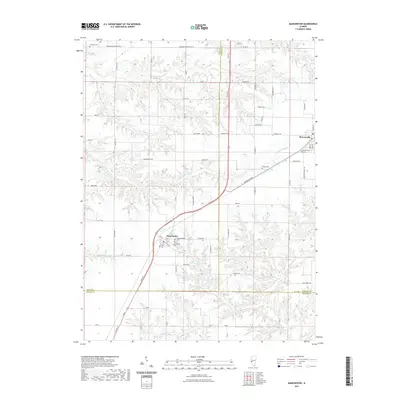
2021 Map of Manchester
USGS Topo · Published 2021About this map
Manchester and Murrayville anchor this western Illinois landscape, where the tri-county boundaries of Scott, Morgan, and Greene counties converge. The terrain is defined by a dense network of drainage, including N Little Sandy Cr and the winding Little Sandy Cr, which have historically shaped the agricultural parceling and road placement in the region. For genealogists and local historians, the area is notably rich in burial sites, featuring the Old Manchester Cem and Manchester Cem near the town center, along with the Murrayville Cem and Bethel Cem to the north and east. The road system, from the primary Main St to rural routes like Woodson Winchester Rd, follows a rigid section-line grid that occasionally yields to the meandering paths of Marks Cr and Birch Cr.
Find a feature on this map
64 named features on this map. Tap any name to fly to it.
Don’t see what you’re looking for? This feature index may not catch every label — zoom into the map to look around manually.
Map Details
Editions of this 2021 Manchester Map
This is the sole edition of this map. No revisions or reprints were ever made.
Other maps of this area

1924 · Winchester
USGS Topo · 1:48,000

1924 · Roodhouse
USGS Topo · 1:62,500

1926 · Winchester
USGS Topo · 1:62,500

1926 · Roodhouse
USGS Topo · 1:62,500

1932 · Greenfield
USGS Topo · 1:62,500

1932 · Jacksonville
USGS Topo · 1:62,500

1937 · Jacksonville
USGS Topo · 1:62,500

1948 · Quincy
USGS Topo · 1:250,000

1956 · Quincy
USGS Topo · 1:250,000
1983 · Alsey
USGS Topo · 1:24,000