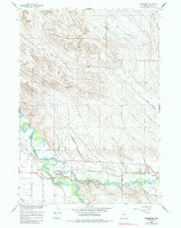
1960 Map of Manderson
USGS Topo · Published 1985About this map
Manderson sits at the confluence where the Nowood River joins the Bighorn River, serving as a central hub for the region's mid-century petroleum and transportation infrastructure. The landscape is defined by its industrial utility, featuring a refinery, a Sulphur Plant, and the extensive Manderson Field. This 1960 era survey reveals the complex network of pipelines that supported the nearby Torchlight Dome Oil Field, illustrating the economic drivers of Big Horn County at this time.
Find a feature on this map
21 named features on this map. Tap any name to fly to it.
Don’t see what you’re looking for? This feature index may not catch every label — zoom into the map to look around manually.
Map Details
Editions of this 1960 Manderson Map
2 editions found
Other maps of this area

1951 · Schuster Flats NE
USGS Topo · 1:24,000

1955 · Cody
USGS Topo · 1:250,000

1955 · Sheridan
USGS Topo · 1:250,000

1958 · Cody
USGS Topo · 1:250,000

1958 · Sheridan
USGS Topo · 1:250,000

1960 · Manderson
USGS Topo · 1:24,000

1960 · Manderson NE
USGS Topo · 1:24,000

1960 · Manderson SE
USGS Topo · 1:24,000

1960 · Wild Horse Flats
USGS Topo · 1:24,000

1962 · Sheridan
USGS Topo · 1:250,000