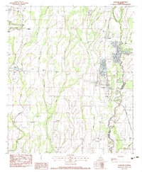
1982 Map of Mangham
USGS Topo · Published 1983About this map
The Missouri Pacific corridor anchors this portion of Northeastern Louisiana, cutting a straight path through a landscape defined by the winding waters of Bee Bayou and Big Creek. This 1982 survey reveals the agricultural and social centers of Mangham and Archibald, where the grid of Minnow Farms suggests a local economy tied to specific land-use patterns of the late 20th century. For those tracing local families, the map is remarkably dense with landmarks, identifying the Mangham Jr High Sch and numerous country congregations like China Grove Ch and Hopewell Ch. The survey also marks the boundary between Richland Parish and Franklin Parish, showing how these political lines intersect with older family-named sites such as Gwin Mem Cem and Brunson Cem. From the banks of the Boeuf River to the small settlement of New Light, the sheet preserves a detailed picture of rural life.
Find a feature on this map
47 named features on this map. Tap any name to fly to it.
Don’t see what you’re looking for? This feature index may not catch every label — zoom into the map to look around manually.
Map Details
Editions of this 1982 Mangham Map
This is the sole edition of this map. No revisions or reprints were ever made.
Other maps of this area

1935 · Winnsboro
USGS Topo · 1:62,500

1935 · Alto
USGS Topo · 1:62,500

1935 · Baskinton
USGS Topo · 1:62,500

1939 · Fort Necessity
USGS Topo · 1:62,500

1955 · Jackson
USGS Topo · 1:250,000

1957 · Mangham
USGS Topo · 1:62,500

1958 · Baskinton
USGS Topo · 1:62,500

1958 · Winnsboro
USGS Topo · 1:62,500

1958 · Fort Necessity
USGS Topo · 1:62,500

1961 · Jackson
USGS Topo · 1:250,000