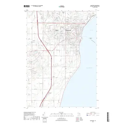
2018 Map of Manitowoc
USGS Topo · Published 2018About this map
The Manitowoc River snakes through the urban heart of Manitowoc before emptying into Maritime Bay, defining the industrial and civic layout of this lakeside community. The city's grid transitions into the rural landscapes of Manitowoc Rapids and Alverno to the west, where a network of small glacial lakes including Silver Lake, Kasbaum Lake, and Weyers Lake punctuate the terrain. To the south, the small settlements of Clover and Duveneck represent the agricultural character of the county. The map detail reflects a modern infrastructure, highlighting the Manitowoc County Airport and a series of local cemeteries like Evergreen Cem and Saint Peter Cem. Along the Lake Michigan shoreline, Manitowoc Shoal stands as a significant navigational feature just off the city's harbor, reminding researchers of the area's deep maritime heritage and its ongoing connection to the Great Lakes.
Find a feature on this map
97 named features on this map. Tap any name to fly to it.
Don’t see what you’re looking for? This feature index may not catch every label — zoom into the map to look around manually.
Map Details
Editions of this 2018 Manitowoc Map
This is the sole edition of this map. No revisions or reprints were ever made.
Other maps of this area

1954 · Manitowoc
USGS Topo · 1:62,500

1954 · Cleveland
USGS Topo · 1:24,000

1954 · St. Wendel
USGS Topo · 1:24,000

1954 · Sheboygan North
USGS Topo · 1:62,500

1954 · Howards Grove
USGS Topo · 1:62,500

1954 · Reedsville
USGS Topo · 1:62,500

1954 · Manitowoc
USGS Topo · 1:24,000

1954 · Milwaukee
USGS Topo · 1:250,000

1954 · Manitowoc
USGS Topo · 1:250,000

1958 · Manitowoc
USGS Topo · 1:250,000