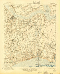
1921 Map of Manning
USGS Topo · Published 1945About this map
Manning serves as the central hub of this South Carolina landscape, where the Atlantic Coast Line and Northwestern Railroad intersect to drive the local economy. The surrounding territory is defined by the expansive Pocotaligo Swamp and Black River Swamp, creating a complex network of wetlands interspersed with named bays such as Buck Bay, Hog Bay, and Sandhill Bay. This 1920s-era survey reveals a densely settled rural community supported by numerous local institutions, including the Wilson Mill School, St Marks School, and Elizabeth School. The prevalence of community landmarks like St Matthews Church and Brewington Church alongside family-named roads like Coleman Road illustrates the established social and genealogical fabric of Clarendon County during this period of Southern agricultural history.
Find a feature on this map
91 named features on this map. Tap any name to fly to it.
Don’t see what you’re looking for? This feature index may not catch every label — zoom into the map to look around manually.
Map Details
Editions of this 1921 Manning Map
3 editions found
Other maps of this area

1920 · Eutawville
USGS Topo · 1:48,000

1920 · Chicora
USGS Topo · 1:48,000

1920 · Mayesville
USGS Topo · 1:48,000

1920 · Manning
USGS Topo · 1:48,000

1921 · Chicora
USGS Topo · 1:62,500

1921 · Manning
USGS Topo · 1:62,500

1921 · Mayesville
USGS Topo · 1:62,500

1921 · Eutawville
USGS Topo · 1:62,500

1943 · Chicora
USGS Topo · 1:62,500

1943 · Mayesville
USGS Topo · 1:62,500