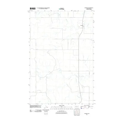
2011 Map of Manning
USGS Topo · Published 2011About this map
Manning serves as the primary hub in this Dunn County landscape, situated where Wolf Creek joins the Knife River. The 2011 survey reveals a vast, structured grid of section-line roads, including 112th Ave SW and 20th St SW, which facilitate movement across the agricultural terrain. The hydrology is dominated by the meandering paths of Crooked Creek and Lighting Creek, which cut through the northern Great Plains topography. This map documents the rural infrastructure of the early 21st century, showing how modern transportation routes like State Highway 22 follow the natural contours of the river valleys while maintaining the rigid geometry of the Public Land Survey System.
Find a feature on this map
17 named features on this map. Tap any name to fly to it.
Don’t see what you’re looking for? This feature index may not catch every label — zoom into the map to look around manually.
Map Details
Editions of this 2011 Manning Map
This is the sole edition of this map. No revisions or reprints were ever made.
Other maps of this area

1953 · Watford City
USGS Topo · 1:250,000

1957 · Watford City
USGS Topo · 1:250,000

1967 · Watford City
USGS Topo · 1:250,000

1973 · Manning SE
USGS Topo · 1:24,000
1973 · New Hradec North
USGS Topo · 1:24,000
1973 · Hirschville SW
USGS Topo · 1:24,000

1973 · Manning
USGS Topo · 1:24,000

1973 · Manning NW
USGS Topo · 1:24,000

1973 · Emerson
USGS Topo · 1:24,000

1973 · Lake Ilo
USGS Topo · 1:24,000