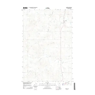
2014 Map of Manning
USGS Topo · Published 2014About this map
Manning serves as the primary focal point of this western North Dakota landscape, situated at a junction near the banks of the Knife River. The 2014 survey documents a territory defined by its drainage systems, where Wolf Cr feeds into the river from the northeast and Crooked Cr winds through the central and western sections. A systematic grid of section-line roads, including 112th Ave SW and 20th St SW, reveals the enduring structure of the rural landscape in Dunn County. This topographic study captures the relationship between the prairie terrain and the watercourses, such as Lighting Cr, that dictate the placement of local infrastructure and land use patterns.
Find a feature on this map
19 named features on this map. Tap any name to fly to it.
Don’t see what you’re looking for? This feature index may not catch every label — zoom into the map to look around manually.
Map Details
Editions of this 2014 Manning Map
This is the sole edition of this map. No revisions or reprints were ever made.
Other maps of this area

1953 · Watford City
USGS Topo · 1:250,000

1957 · Watford City
USGS Topo · 1:250,000

1967 · Watford City
USGS Topo · 1:250,000

1973 · Manning SE
USGS Topo · 1:24,000
1973 · New Hradec North
USGS Topo · 1:24,000
1973 · Hirschville SW
USGS Topo · 1:24,000

1973 · Manning
USGS Topo · 1:24,000

1973 · Manning NW
USGS Topo · 1:24,000

1973 · Emerson
USGS Topo · 1:24,000

1973 · Lake Ilo
USGS Topo · 1:24,000