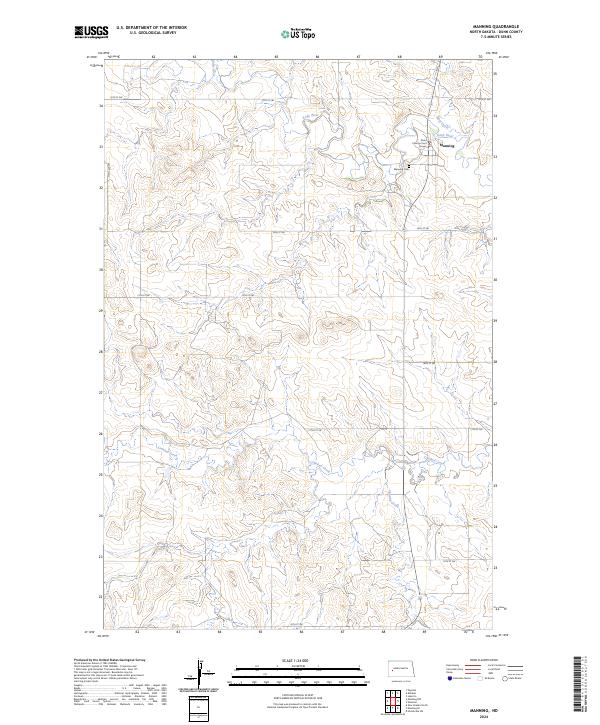
2024 Map of Manning
USGS Topo · Published 2024About this map
Manning serves as the focal point of this Dunn County landscape, situated where Wolf Creek meets the Knife River. As the county seat, the town is anchored by the Dunn County Court House, which stands near the intersection of the region's section-line road network. The terrain is defined by the drainage patterns of several seasonal and permanent waterways, including Crooked Creek in the south and Lightning Creek to the southeast. Outside the small residential cluster of the town, the map reveals a sparsely populated agricultural environment organized by the Public Land Survey System. Genealogists will find the Manning Cem located just southwest of the main settlement, providing a primary point for local family history research. The layout of rural routes like 12th St SW and 113th Ave SW illustrates the grid-based settlement pattern characteristic of the North Dakota plains.
Find a feature on this map
21 named features on this map. Tap any name to fly to it.
Don’t see what you’re looking for? This feature index may not catch every label — zoom into the map to look around manually.
Map Details
Editions of this 2024 Manning Map
This is the sole edition of this map. No revisions or reprints were ever made.
Other maps of this area

1953 · Watford City
USGS Topo · 1:250,000

1957 · Watford City
USGS Topo · 1:250,000

1967 · Watford City
USGS Topo · 1:250,000

1973 · Manning SE
USGS Topo · 1:24,000
1973 · New Hradec North
USGS Topo · 1:24,000
1973 · Hirschville SW
USGS Topo · 1:24,000

1973 · Manning
USGS Topo · 1:24,000

1973 · Manning NW
USGS Topo · 1:24,000

1973 · Emerson
USGS Topo · 1:24,000

1973 · Lake Ilo
USGS Topo · 1:24,000