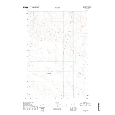
2017 Map of Manning SE
USGS Topo · Published 2017About this map
Russian Spring Cr and Lighting Cr carve a network of drainage patterns across this section of Dunn County, defining the character of the rural landscape south of Manning. This 2017 survey reflects a largely agricultural expanse where section lines dictate the modern road grid, including 23rd St SW and 27th St SW. A singular aviation landmark, Wolberg's Private Airport, sits in the eastern reaches of the quadrangle near Deep Cr. The map preserves the Public Land Survey System boundaries for townships including t142n r96w and t141n r95w, providing a clear view of the land divisions and intermittent watercourses that have shaped ranching and farming in this portion of the North Dakota badlands fringe.
Find a feature on this map
15 named features on this map. Tap any name to fly to it.
Don’t see what you’re looking for? This feature index may not catch every label — zoom into the map to look around manually.
Map Details
Editions of this 2017 Manning SE Map
This is the sole edition of this map. No revisions or reprints were ever made.
Other maps of this area

1953 · Dickinson
USGS Topo · 1:250,000

1953 · Watford City
USGS Topo · 1:250,000

1957 · Dickinson
USGS Topo · 1:250,000

1957 · Watford City
USGS Topo · 1:250,000

1959 · Dickinson North
USGS Topo · 1:24,000

1962 · Davis Buttes
USGS Topo · 1:24,000

1967 · Watford City
USGS Topo · 1:250,000

1973 · Manning SE
USGS Topo · 1:24,000

1973 · New Hradec South
USGS Topo · 1:24,000
1973 · New Hradec North
USGS Topo · 1:24,000