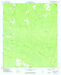
1977 Map of Manningtown
USGS Topo · Published 1978About this map
Manningtown and its surrounding wetlands define this portion of Wayne County during the mid-1970s. The landscape is dominated by the intricate hydrology of the Penholoway Bay and the winding course of Penholoway Creek, which is crossed by the historically named Rosin Ford. This area exhibits a distinct pattern of 'islands'—elevated ground within the marshy lowlands—such as Strickland Island, Downing Island, and Palmetto Island, many of which are accessed by a network of timber and access roads like Pendarvis Road. Local community life is anchored by the Little Creek Ch and a nearby Cem in the settlement, while the Southern railroad corridor skirts the northeastern edge of the quadrangle. The map captures an era of rural Georgia where the logging and turpentine history is reflected in names like Big Cypress Swamp and Little Okefenokee Swamp.
Find a feature on this map
27 named features on this map. Tap any name to fly to it.
Don’t see what you’re looking for? This feature index may not catch every label — zoom into the map to look around manually.
Map Details
Editions of this 1977 Manningtown Map
2 editions found
Other maps of this area

1918 · Jesup
USGS Topo · 1:62,500

1918 · Hortense
USGS Topo · 1:62,500

1918 · Everett City
USGS Topo · 1:62,500

1920 · Everett City
USGS Topo · 1:62,500

1943 · Ludowici
USGS Topo · 1:62,500

1943 · Jesup
USGS Topo · 1:62,500

1944 · Everett City
USGS Topo · 1:62,500

1944 · Hortense
USGS Topo · 1:62,500

1946 · Brunswick
USGS Topo · 1:250,000

1948 · Brunswick
USGS Topo · 1:250,000