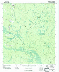
1988 Map of Manningtown
USGS Topo · Published 1995About this map
Manningtown and its surrounding wetlands occupy a landscape defined by expansive bays and intricate drainage systems in Wayne County. This survey, revised from mid-1970s and early-1990s data, illustrates the transition of the South Georgia interior, where family-named roads like Flowers Road and Pendarvis Road cut through low-lying terrain. The northern section is anchored by the Little Creek Ch and several cemeteries, providing important markers for those researching local family lineages and rural settlement patterns.
Find a feature on this map
29 named features on this map. Tap any name to fly to it.
Don’t see what you’re looking for? This feature index may not catch every label — zoom into the map to look around manually.
Map Details
Editions of this 1988 Manningtown Map
This is the sole edition of this map. No revisions or reprints were ever made.
Other maps of this area

1918 · Jesup
USGS Topo · 1:62,500

1918 · Hortense
USGS Topo · 1:62,500

1918 · Everett City
USGS Topo · 1:62,500

1920 · Everett City
USGS Topo · 1:62,500

1943 · Ludowici
USGS Topo · 1:62,500

1943 · Jesup
USGS Topo · 1:62,500

1944 · Everett City
USGS Topo · 1:62,500

1944 · Hortense
USGS Topo · 1:62,500

1946 · Brunswick
USGS Topo · 1:250,000

1948 · Brunswick
USGS Topo · 1:250,000