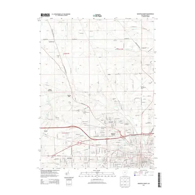
2013 Map of Mansfield North
USGS Topo · Published 2013About this map
The northern reaches of Mansfield and the neighboring city of Ontario are defined by a mix of educational campuses and commercial infrastructure. This area includes the North Central State College and the Ohio State University-Mansfield Campus, alongside the prominent Richland Mall shopping district. The landscape transition from the dense residential developments of Sunnyview and Midpoint Woods toward the more rural northern townships is marked by numerous family and memorial burial grounds, including the Zeiter Cemetery and the Clay Memorial Cemetery. To the east, the large footprint of the Mansfield Lahm Regional Airport and the Ohio State Reformatory Cemetery dominate the local geography, while the Springmill Drive-In remains a notable landmark of the local entertainment culture in the north-central portion of the quadrangle.
Find a feature on this map
206 named features on this map. Tap any name to fly to it.
Don’t see what you’re looking for? This feature index may not catch every label — zoom into the map to look around manually.
Map Details
Editions of this 2013 Mansfield North Map
This is the sole edition of this map. No revisions or reprints were ever made.
Other maps of this area

1908 · Ashland
USGS Topo · 1:62,500

1912 · Perrysville
USGS Topo · 1:62,500

1915 · Crestline
USGS Topo · 1:62,500

1915 · Perrysville
USGS Topo · 1:62,500

1915 · Shauck
USGS Topo · 1:62,500

1943 · Shauck
USGS Topo · 1:62,500

1943 · Crestline
USGS Topo · 1:62,500

1944 · Perrysville
USGS Topo · 1:62,500

1950 · Marion
USGS Topo · 1:250,000
1960 · Shelby
USGS Topo · 1:24,000