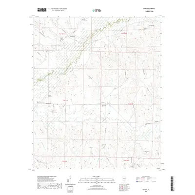
2020 Map of Mantua
USGS Topo · Published 2020About this map
Sipsey River meanders across the border of Pickens and Greene counties, defining the low-lying drainage patterns of this rural Alabama landscape. The settlement of Mantua serves as a central point for a network of local routes including Joseph Wilder Rd and M L King Hwy. This modern survey reveals a high density of rural burial grounds, such as Bethesda Church Yard Cem and Mount Moriah Cem, which are often the most enduring markers of nineteenth-century family homesteads and community hubs. Small creek systems like Brush Cr and Smith Br feed into the river basin, while the township and range lines of the Public Land Survey System provide the underlying geometry for the scattered hamlets of Benevola, Snoddy, and Union. The distribution of these named points suggests a long-standing pattern of agricultural land use and localized social centers linked by county roads.
Find a feature on this map
55 named features on this map. Tap any name to fly to it.
Don’t see what you’re looking for? This feature index may not catch every label — zoom into the map to look around manually.
Map Details
Editions of this 2020 Mantua Map
This is the sole edition of this map. No revisions or reprints were ever made.
Other maps of this area

1927 · Eutaw
USGS Topo · 1:48,000

1931 · Eutaw
USGS Topo · 1:62,500

1953 · Montgomery
USGS Topo · 1:250,000

1953 · Birmingham
USGS Topo · 1:250,000

1953 · Meridian
USGS Topo · 1:250,000

1953 · West Point
USGS Topo · 1:250,000

1956 · Birmingham
USGS Topo · 1:250,000

1956 · Montgomery
USGS Topo · 1:250,000

1957 · Birmingham
USGS Topo · 1:250,000

1957 · Meridian
USGS Topo · 1:250,000