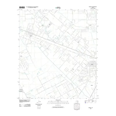
2010 Map of Manvel
USGS Topo · Published 2010About this map
Mustang Bayou and Chocolate Bayou wind through the coastal prairie of Brazoria County, anchoring a landscape defined by traditional settlement patterns and mid-twentieth-century aviation. The city of Manvel serves as a primary hub, located near the Manvel Cemetery and the private Wolfe Air Park. To the southeast, the growing outskirts of Alvin are visible, including the neighborhood of Hillcrest and the Alvin Airpark. The area's agricultural and industrial heritage is represented by the Briscoe Canal and the Hastings Siding along the railroad corridor. Smaller residential developments like The Heights are situated between the bayous, illustrating the residential expansion common to this region as it transitioned from open ranch land to suburban communities.
Find a feature on this map
74 named features on this map. Tap any name to fly to it.
Don’t see what you’re looking for? This feature index may not catch every label — zoom into the map to look around manually.
Map Details
Editions of this 2010 Manvel Map
This is the sole edition of this map. No revisions or reprints were ever made.
Other maps of this area

1916 · Genoa
USGS Topo · 1:24,000

1920 · Genoa
USGS Topo · 1:31,680

1920 · Mykawa
USGS Topo · 1:31,680

1920 · Almeda
USGS Topo · 1:31,680

1929 · Algoa
USGS Topo · 1:24,000

1932 · Algoa
USGS Topo · 1:31,680
1932 · Genoa
USGS Topo · 1:31,680

1932 · Mustang Bayou
USGS Topo · 1:31,680

1943 · Rosharon
USGS Topo · 1:31,680

1943 · Mustang Bayou
USGS Topo · 1:31,680