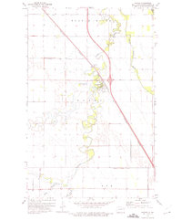
1973 Map of Manvel
USGS Topo · Published 1975About this map
Manvel serves as the central hub of this Red River Valley landscape, situated where the Burlington Northern railroad corridor meets the meandering path of the Turtle River. The township organization is clearly delineated through the boundaries of Ferry, Blooming, and Rye, reflecting the orderly agricultural platting of Grand Forks County. Local landmarks like St Timothy Cem and Ray Ronan Park provide points of interest for genealogists and local historians, while the technical infrastructure of the era is represented by the Gaging Station and several Sewage Disposal Ponds. The terrain is defined by its drainage systems, featuring several large-scale civil engineering projects such as County DITCH No 1 and County Ditch No 32, which sit alongside natural features like Kelly Slough and the Salt Water Coulee.
Find a feature on this map
20 named features on this map. Tap any name to fly to it.
Don’t see what you’re looking for? This feature index may not catch every label — zoom into the map to look around manually.
Map Details
Editions of this 1973 Manvel Map
This is the sole edition of this map. No revisions or reprints were ever made.
Other maps of this area

1926 · Ardoch
USGS Topo · 1:62,500

1934 · Emerado
USGS Topo · 1:48,000

1934 · Grand Forks
USGS Topo · 1:24,000

1934 · Grand Forks
USGS Topo · 1:62,500

1936 · Emerado
USGS Topo · 1:62,500

1938 · Grand Forks
USGS Topo · 1:62,500

1952 · Grand Forks
USGS Topo · 1:250,000

1952 · Thief River Falls
USGS Topo · 1:250,000

1956 · Thief River Falls
USGS Topo · 1:250,000

1956 · Grand Forks
USGS Topo · 1:250,000