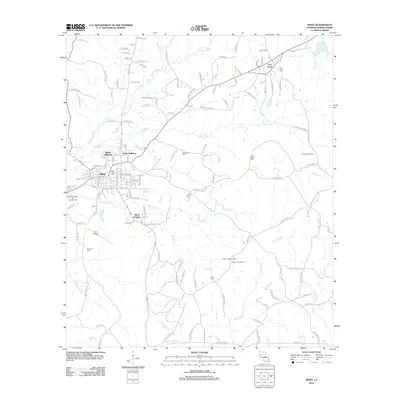
2012 Map of Many
USGS Topo · Published 2012About this map
The parish seat of Many anchors the western edge of this Sabine Parish landscape, where residential developments like Blakes Addition and Alford Heights meet the local aviation hub at Hart Airport. To the northeast, the settlement of Fort Jesup preserves a name deeply tied to frontier history, surrounded by a network of rural cemeteries including Fort Jesup Cem and Hope Castle Cem. The terrain is defined by the winding paths of Harpoon Bayou and Blackwell Creek, which drain a landscape marked by industrial activity at the Fort Jesup Oil Field and the Pendleton-Many Oil and Gas Field. Farther south, the wooded ridges around Fisher Lookout Tower overlook the confluence of Clear Branch and Strickland Branch, illustrating the area's timber and forest management heritage.
Find a feature on this map
138 named features on this map. Tap any name to fly to it.
Don’t see what you’re looking for? This feature index may not catch every label — zoom into the map to look around manually.
Map Details
Editions of this 2012 Many Map
This is the sole edition of this map. No revisions or reprints were ever made.
Other maps of this area

1941 · Zwolle
USGS Topo · 1:62,500

1942 · Many
USGS Topo · 1:62,500

1942 · Florien
USGS Topo · 1:62,500

1943 · Many
USGS Topo · 1:62,500

1944 · Negreet
USGS Topo · 1:62,500

1944 · Florien
USGS Topo · 1:62,500

1944 · Zwolle
USGS Topo · 1:62,500

1953 · Alexandria
USGS Topo · 1:250,000

1954 · Florien
USGS Topo · 1:62,500
1954 · Florien
USGS Topo · 1:24,000