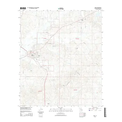
2015 Map of Many
USGS Topo · Published 2015About this map
The town of Many serves as the central hub for this Sabine Parish landscape, where the street grid of the parish seat meets the winding tributaries of the Red River basin. To the northeast, the settlement of Fort Jesup preserves the location of the early frontier outpost, accompanied by the Fort Jesup Cem. The map reveals a high concentration of small family and community burial grounds, including Jerusalem Cem, Hope Castle Cem, and Muse Cem, which are often located near the headwaters of local streams like Blackwell Cr and San Jose Cr. To the south, the village of Fisher marks the lower reaches of the quadrangle near Negreet Cr. The terrain is defined by a dense network of local roads and creek systems, such as Edmondson Cr and Turpentine Br, illustrating a rural development pattern centered on small crossroads and water access.
Find a feature on this map
50 named features on this map. Tap any name to fly to it.
Don’t see what you’re looking for? This feature index may not catch every label — zoom into the map to look around manually.
Map Details
Editions of this 2015 Many Map
This is the sole edition of this map. No revisions or reprints were ever made.
Other maps of this area

1941 · Zwolle
USGS Topo · 1:62,500

1942 · Many
USGS Topo · 1:62,500

1942 · Florien
USGS Topo · 1:62,500

1943 · Many
USGS Topo · 1:62,500

1944 · Negreet
USGS Topo · 1:62,500

1944 · Florien
USGS Topo · 1:62,500

1944 · Zwolle
USGS Topo · 1:62,500

1953 · Alexandria
USGS Topo · 1:250,000

1954 · Florien
USGS Topo · 1:62,500
1954 · Florien
USGS Topo · 1:24,000