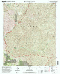
1995 Map of Manzanita Mountain
USGS Topo · Published 2000About this map
The Sierra Madre Mts define the northern reaches of this territory, where remote drainage systems like La Brea Creek and Salsipuedes Creek carve deep through the landscape. This 1995 revision by the USDA Forest Service documents the protected expanses of the Los Padres National Forest and the San Rafael Wilderness, characterized by a complex network of canyons such as Script Canyon and Stag Canyon. A notable point of human activity is the White Elephant Mine, situated east of the Kerry Canyon Campsite.
Find a feature on this map
31 named features on this map. Tap any name to fly to it.
Don’t see what you’re looking for? This feature index may not catch every label — zoom into the map to look around manually.
Map Details
Editions of this 1995 Manzanita Mountain Map
This is the sole edition of this map. No revisions or reprints were ever made.
Other maps of this area

1902 · Santa Ynez
USGS Topo · 1:125,000

1905 · Santa Ynez
USGS Topo · 1:125,000

1905 · Lompoc
USGS Topo · 1:125,000

1912 · McKittrick
USGS Topo · 1:125,000

1937 · Branch Mtn
USGS Topo · 1:48,000

1941 · Caliente Mountain
USGS Topo · 1:62,500

1941 · McPherson Peak
USGS Topo · 1:62,500

1942 · Lompoc
USGS Topo · 1:125,000

1942 · Branch Mountain
USGS Topo · 1:62,500

1942 · Caliente Mtn
USGS Topo · 1:62,500