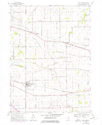
1968 Map of Maple Park
USGS Topo · Published 1977About this map
The Chicago and North Western railway anchors this section of the Northern Illinois prairie, connecting the small agrarian hubs of Maple Park, Virgil, and the crossroads at Richardson. The landscape is defined by an orderly grid of family-named roads such as Mc Gough Road, Peplow Road, and Thomas Road, which serve the scattered farmsteads and rural cemeteries of the late 1960s.
Find a feature on this map
61 named features on this map. Tap any name to fly to it.
Don’t see what you’re looking for? This feature index may not catch every label — zoom into the map to look around manually.
Map Details
Editions of this 1968 Maple Park Map
2 editions found
Other maps of this area

1925 · Elgin
USGS Topo · 1:62,500

1932 · Geneva
USGS Topo · 1:62,500

1937 · Sycamore
USGS Topo · 1:62,500

1938 · Genoa
USGS Topo · 1:62,500

1940 · Elgin
USGS Topo · 1:62,500

1948 · Geneva
USGS Topo · 1:62,500

1954 · Rockford
USGS Topo · 1:250,000

1955 · Rockford
USGS Topo · 1:250,000

1958 · Aurora
USGS Topo · 1:250,000

1958 · Rockford
USGS Topo · 1:250,000