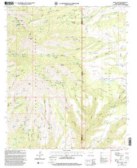
1997 Map of Maple Peak
USGS Topo · Published 2000About this map
Apache National Forest and Gila National Forest converge at the high-desert borderlands of Arizona and New Mexico, centered on the prominent heights of Maple Peak. The landscape is a network of deep canyons and expansive plateaus, including Smoothing Iron Mesa and Snare Mesa. Human presence in this environment is marked by high-altitude ranching and water management, evidenced by the Coalson Ranch and an extensive series of tanks and springs like Hobo No 3 Tank, Apple Orchard Spring, and Kelly Well Spring. These water sources were critical for sustaining life and livestock across the varied topography of Rincon Flats and Webster Mountain. A single Grave noted near the ranching areas provides a quiet connection to the families who navigated this difficult terrain. The survey captures the complex boundary between Greenlee Co and Catron Co, where primitive roads trace the contours of Charlie Moore Mountain and Bullard Peak.
Find a feature on this map
138 named features on this map. Tap any name to fly to it.
Don’t see what you’re looking for? This feature index may not catch every label — zoom into the map to look around manually.
Map Details
Editions of this 1997 Maple Peak Map
This is the sole edition of this map. No revisions or reprints were ever made.
Other maps of this area

1910 · Mogollon
USGS Topo · 1:125,000

1912 · Mogollon
USGS Topo · 1:125,000

1913 · Morenci
USGS Topo · 1:125,000

1915 · Morenci
USGS Topo · 1:125,000

1954 · Clifton
USGS Topo · 1:250,000

1957 · Clifton
USGS Topo · 1:250,000

1958 · Clifton
USGS Topo · 1:250,000

1962 · Clifton
USGS Topo · 1:250,000

1962 · Big Lue Mts
USGS Topo · 1:62,500
1963 · Alma
USGS Topo · 1:24,000