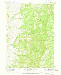
1969 Map of Mapleton
USGS Topo · Published 1973About this map
The Cub River and Worm Creek drain the western slopes of the Bear River Range in this detailed survey of Franklin County, Idaho. High-altitude hydrology is a central theme, as the map tracks a complex network of springs and irrigation infrastructure necessary for life in the high valley, including the Middle Canal and Ditch. Small settlements like Mapleton and Cherryville anchor the flatter terrain to the west, while the eastern portion climbs into the Cache National Forest. The landscape is marked by family-named landmarks such as Chatterton Spring, Paul Jones Spring, and Baker Spring. A heavy reliance on backcountry transportation is evident from the extensive network of labels for Jeep Tr, Pack Trail, and Trail that weave through named canyons and over Morgan Ridge toward Camp Wilderness.
Find a feature on this map
48 named features on this map. Tap any name to fly to it.
Don’t see what you’re looking for? This feature index may not catch every label — zoom into the map to look around manually.
Map Details
Editions of this 1969 Mapleton Map
3 editions found
Other maps of this area

1914 · Logan
USGS Topo · 1:125,000

1915 · Preston
USGS Topo · 1:96,000

1916 · Logan
USGS Topo · 1:125,000

1918 · Preston
USGS Topo · 1:125,000

1954 · Ogden
USGS Topo · 1:250,000

1955 · Preston
USGS Topo · 1:250,000

1958 · Ogden
USGS Topo · 1:250,000

1958 · Preston
USGS Topo · 1:250,000

1960 · Ogden
USGS Topo · 1:250,000

1962 · Preston
USGS Topo · 1:250,000