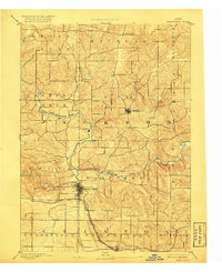
1891 Map of Maquoketa
USGS Topo · Published 1917About this map
Maquoketa serves as the primary hub in this late 19th-century landscape, positioned where the Chicago and North Western Railroad and the Chicago Milwaukee and St Paul Railroad intersect. The town's grid is clearly defined, situated south of the confluence of the North Fork Maquoketa River and the main stem of the Maquoketa River. The surrounding terrain is a network of township boundaries like Perry, Richland, and Farmers Creek, reflecting the early administrative organization of eastern Iowa. Smaller outposts like Andrew and Fulton are connected by a web of primitive roads that follow the ridgelines between drainage basins. To the north, Otter Creek and White Water Creek carve through the landscape, while Delmar sits at the southern edge near the border of Clinton and Jackson counties.
Find a feature on this map
26 named features on this map. Tap any name to fly to it.
Don’t see what you’re looking for? This feature index may not catch every label — zoom into the map to look around manually.
Map Details
Editions of this 1891 Maquoketa Map
3 editions found
Other maps of this area

1891 · DeWitt
USGS Topo · 1:62,500

1891 · Maquoketa
USGS Topo · 1:62,500

1891 · Baldwin
USGS Topo · 1:62,500

1892 · Wheatland
USGS Topo · 1:62,500

1892 · Goose Lake
USGS Topo · 1:62,500

1894 · Wheatland
USGS Topo · 1:62,500

1894 · Goose Lake
USGS Topo · 1:62,500

1899 · Clinton
USGS Topo · 1:125,000

1901 · Peosta
USGS Topo · 1:125,000

1901 · Rock Island
USGS Topo · 1:125,000