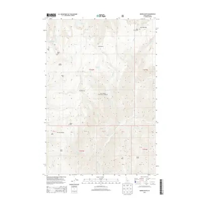
2013 Map of Marble Butte
USGS Topo · Published 2013About this map
Nez Perce National Forest dominates this Idaho landscape, characterized by high-elevation ridges and mountain peaks. Prominent landmarks such as Square Mtn, Sheep Mtn, and the namesake Marble Butte define the horizon. The drainage network is dense, with Slaughter Cr and Sheep Cr carving deep paths through the terrain. These waterways are fed by numerous smaller streams and alpine water sources including Twin Lakes, Hidden Lake, and Sweet Arise Spring. Isolated meadows like Anchor Meadow, Long Meadow, and Porcupine Meadow provide breaks in the forested slopes, while Plummer Point and Bear Grass Ridge offer vantage points over the surrounding wilderness. The map details a remote section of Idaho County where the only human imprints are the Forest Service roads and trails that traverse the steep elevation changes between North Butte and Elk Butte.
Find a feature on this map
31 named features on this map. Tap any name to fly to it.
Don’t see what you’re looking for? This feature index may not catch every label — zoom into the map to look around manually.
Map Details
Editions of this 2013 Marble Butte Map
This is the sole edition of this map. No revisions or reprints were ever made.
Other maps of this area

1931 · Buffalo Hump
USGS Topo · 1:125,000

1934 · Buffalo Hump
USGS Topo · 1:125,000

1956 · Burgdorf
USGS Topo · 1:62,500

1956 · Warren
USGS Topo · 1:62,500

1956 · Elk City
USGS Topo · 1:250,000

1960 · Elk City
USGS Topo · 1:250,000

1963 · Sourdough Peak
USGS Topo · 1:24,000

1963 · Hanover Mtn.
USGS Topo · 1:24,000

1963 · Marble Butte
USGS Topo · 1:24,000
1963 · Sawyer Ridge
USGS Topo · 1:24,000