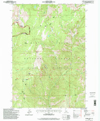
1995 Map of Marble Butte
USGS Topo · Published 1999About this map
The Gospel Hump Wilderness dominates this mid-1990s survey, a high-altitude landscape defined by steep drainages and prominent peaks within the Nez Perce National Forest. The map centers on the namesake Marble Butte and the nearby Elk Butte, showing a terrain largely inaccessible by road, where transit is restricted to trails and natural corridors. Water features are concentrated in the north and west, including Twin Lakes, Square Mountain Lake, and Hidden Lake, which feed a network of creeks like Anchor Creek and Sheep Creek as they descend toward the Salmon River to the southwest. Significant meadows such as Anchor Meadow and Porcupine Meadow provide distinct breaks in the dense forest cover. This map captures the region's character as a preserved wilderness, highlighting the relationship between the Grass Ridge heights and the deep-cut river canyons below.
Find a feature on this map
46 named features on this map. Tap any name to fly to it.
Don’t see what you’re looking for? This feature index may not catch every label — zoom into the map to look around manually.
Map Details
Editions of this 1995 Marble Butte Map
This is the sole edition of this map. No revisions or reprints were ever made.
Other maps of this area

1931 · Buffalo Hump
USGS Topo · 1:125,000

1934 · Buffalo Hump
USGS Topo · 1:125,000

1956 · Burgdorf
USGS Topo · 1:62,500

1956 · Warren
USGS Topo · 1:62,500

1956 · Elk City
USGS Topo · 1:250,000

1960 · Elk City
USGS Topo · 1:250,000

1963 · Sourdough Peak
USGS Topo · 1:24,000

1963 · Hanover Mtn.
USGS Topo · 1:24,000

1963 · Marble Butte
USGS Topo · 1:24,000
1963 · Sawyer Ridge
USGS Topo · 1:24,000