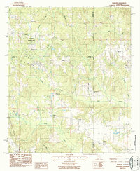
1987 Map of Marbury
USGS Topo · Published 1987About this map
Confederate Memorial Park anchors the northern landscape of this region, situated where the borders of Chilton, Autauga, and Elmore counties converge. The topography is defined by the winding paths of Shoal Creek and Mortar Creek, which dictate the placement of small communities like Marbury, Wadsworth, and Rollins. The CSX railroad corridor runs northwest to southeast, historically linking these settlements and providing a transport backbone for the local timber and gravel industries, evidenced by a Gravel Pit located near the railway.
Find a feature on this map
40 named features on this map. Tap any name to fly to it.
Don’t see what you’re looking for? This feature index may not catch every label — zoom into the map to look around manually.
Map Details
Editions of this 1987 Marbury Map
This is the sole edition of this map. No revisions or reprints were ever made.
Other maps of this area

1891 · Clanton
USGS Topo · 1:125,000

1901 · Wetumpka
USGS Topo · 1:125,000

1903 · Wetumpka
USGS Topo · 1:125,000

1953 · Montgomery
USGS Topo · 1:250,000

1956 · Montgomery
USGS Topo · 1:250,000

1957 · Montgomery
USGS Topo · 1:250,000

1959 · Billingsley
USGS Topo · 1:62,500

1959 · Elmore
USGS Topo · 1:62,500

1971 · Richville
USGS Topo · 1:24,000
1971 · Mitchell Dam
USGS Topo · 1:24,000