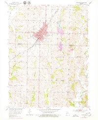
1953 Map of Marceline
USGS Topo · Published 1979About this map
Marceline serves as the focal point of this mid-century survey, its urban grid defined by the heavy presence of the Atchison Topeka and Santa Fe railroad corridor. The town layout is dense with local institutions, including Park Sch, St Bonaventure Ch, and several community burial grounds such as Elmwood Cem and Roselawn Cem. Industrial and infrastructure development is evident in the nearby Marceline Airport, clusters of Oil Tanks, and a local Quarry.
Find a feature on this map
26 named features on this map. Tap any name to fly to it.
Don’t see what you’re looking for? This feature index may not catch every label — zoom into the map to look around manually.
Map Details
Editions of this 1953 Marceline Map
2 editions found
Other maps of this area

1946 · Brookfield
USGS Topo · 1:62,500

1948 · Brookfield
USGS Topo · 1:62,500

1949 · Indian Grove
USGS Topo · 1:24,000

1949 · Rothville
USGS Topo · 1:24,000

1949 · Bucklin
USGS Topo · 1:24,000

1950 · Bucklin
USGS Topo · 1:24,000

1950 · New Cambria West
USGS Topo · 1:24,000

1950 · Rothville
USGS Topo · 1:24,000

1953 · Moberly
USGS Topo · 1:250,000

1953 · Marceline
USGS Topo · 1:24,000