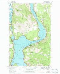
1969 Map of Marcus
USGS Topo · Published 1986About this map
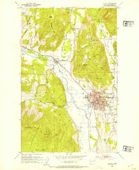
The Columbia River and its massive impoundment, Franklin D Roosevelt Lake, dominate this northern Washington landscape as it appeared in the late 1960s. The town of Marcus and the smaller settlement of Bossburg sit along the eastern shores, where the Burlington Northern railroad follows the river's path. Cultural history is anchored at the southern edge of the map by the St Pauls Mission State Historical Site, while the rugged hills of the Kelly Hill and Gold Hill ranges reveal a landscape defined by resource extraction. Local industrial sites like the Napoleon Mine, Gold Ledge Mine, and Columbia Quarry are clearly marked. The map also captures the distinct shoreline features created by the damming of the river, including Kamloops Island and Marcus Island.
Find a feature on this map
51 named features on this map. Tap any name to fly to it.
Don’t see what you’re looking for? This feature index may not catch every label — zoom into the map to look around manually.
Map Details
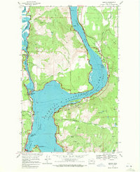
Editions of this 1969 Marcus Map
2 editions found
Other maps of this area

1929 · Colville
USGS Topo · 1:125,000

1933 · Colville
USGS Topo · 1:125,000

1936 · Marcus
USGS Topo · 1:96,000

1942 · Marcus
USGS Topo · 1:125,000

1948 · Kettle Falls
USGS Topo · 1:62,500

1948 · Orient
USGS Topo · 1:62,500

1951 · Orient
USGS Topo · 1:62,500
1951 · Kettle Falls
USGS Topo · 1:62,500
1952 · Echo Valley
USGS Topo · 1:24,000
1952 · Colville
USGS Topo · 1:24,000