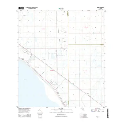
2015 Map of Marcy
USGS Topo · Published 2015About this map
Lake Okeechobee defines the southwestern edge of this Florida landscape, where the Florida National Scenic Trail traces the levee overlooking the water. The survey reveals a region structured by agricultural drainage and transport, centered on the intersection of SR-710 and the county lines of Martin, Okeechobee, and St. Lucie. The small settlement of Marcy sits along the rail line near the Martin County boundary, while Up the Grove Beach and the Flying Cow Air Ranch occupy the shore-facing lands further north. This is a country of sloughs and creeks, where Nubbin Slough, Henry Cr, and Lettuce Cr weave through the township sections toward the lake. To the north, the wooded rise of Jones Hammock stands out against the grid of canal-side roads and rural estates that characterize the inland terrain.
Find a feature on this map
51 named features on this map. Tap any name to fly to it.
Don’t see what you’re looking for? This feature index may not catch every label — zoom into the map to look around manually.
Map Details
Editions of this 2015 Marcy Map
This is the sole edition of this map. No revisions or reprints were ever made.
Other maps of this area

1952 · Okeechobee
USGS Topo · 1:24,000

1953 · Okeechobee 4 SW
USGS Topo · 1:24,000

1953 · Okeechobee 4 SE
USGS Topo · 1:24,000

1953 · Okeechobee 1 SE
USGS Topo · 1:24,000

1953 · Okeechobee 4 NE
USGS Topo · 1:24,000

1953 · Okeechobee 4 NW
USGS Topo · 1:24,000

1953 · Okeechobee 1 SW
USGS Topo · 1:24,000

1953 · Taylor Creek SE
USGS Topo · 1:24,000

1956 · Fort Pierce
USGS Topo · 1:250,000

1958 · Fort Pierce
USGS Topo · 1:250,000