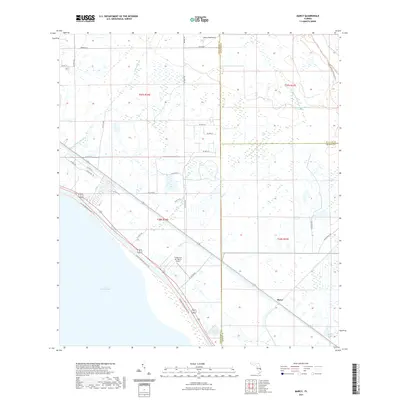
2021 Map of Marcy
USGS Topo · Published 2021About this map
Lake Okeechobee dominates the southwestern corner of this coastal-adjacent landscape, where the waters meet a network of canals and natural drainages at the convergence of Martin, St. Lucie, and Okeechobee counties. The small settlement of Marcy sits at a rail junction near the lake's edge, while Jones Hammock occupies the northern reaches of the quadrangle. The terrain is characterized by intricate water management and agricultural boundaries, evidenced by the presence of Nubbin Slough and Myrtle Slough. Recreation and preservation are prominent features of the modern era, with the Florida National Scenic Trail skirting the lakefront and the Bluefield Ranch Preserve Trail winding through the northeastern corner. Aviation history is noted by the Flying Cow Air Ranch Airport, positioned along Lettuce Cr amidst a grid of rural roads and section lines.
Find a feature on this map
40 named features on this map. Tap any name to fly to it.
Don’t see what you’re looking for? This feature index may not catch every label — zoom into the map to look around manually.
Map Details
Editions of this 2021 Marcy Map
This is the sole edition of this map. No revisions or reprints were ever made.
Other maps of this area

1952 · Okeechobee
USGS Topo · 1:24,000

1953 · Okeechobee 4 SW
USGS Topo · 1:24,000

1953 · Okeechobee 4 SE
USGS Topo · 1:24,000

1953 · Okeechobee 1 SE
USGS Topo · 1:24,000

1953 · Okeechobee 4 NE
USGS Topo · 1:24,000

1953 · Okeechobee 4 NW
USGS Topo · 1:24,000

1953 · Okeechobee 1 SW
USGS Topo · 1:24,000

1953 · Taylor Creek SE
USGS Topo · 1:24,000

1956 · Fort Pierce
USGS Topo · 1:250,000

1958 · Fort Pierce
USGS Topo · 1:250,000