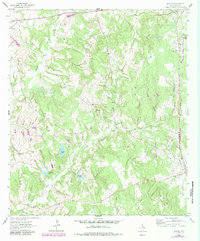
1964 Map of Margie
USGS Topo · Published 1983About this map
Leon County's rolling hills and dense woodlands are defined by a network of creek branches in this 1960s study, updated with photorevisions in the early 1980s. The settlement of Margie sits along the Burlington Northern railroad corridor, while Flynn appears in the southeastern corner. This landscape is a patchwork of family-named water bodies and rural community landmarks, including Old Beulah Ch and Clear Creek Ch. Local cemeteries like White Cem and Green Cem are preserved in their rural settings, offering specific points of interest for genealogists tracing Leon County roots. Industrial activity is visible through Gravel Pits, while recreational or livestock water sources like Chaney Lake, Ponderosa Lake, and Grimes Lake punctuate the drainage basins of Clear Creek and Brushy Creek.
Find a feature on this map
26 named features on this map. Tap any name to fly to it.
Don’t see what you’re looking for? This feature index may not catch every label — zoom into the map to look around manually.
Map Details
Editions of this 1964 Margie Map
2 editions found

Other maps of this area

1925 · Marquez No. 1
USGS Topo · 1:48,000

1925 · Marquez No. 4
USGS Topo · 1:48,000

1927 · Marquez
USGS Topo · 1:62,500

1930 · Marquez
USGS Topo · 1:62,500

1954 · Waco
USGS Topo · 1:250,000

1955 · Waco
USGS Topo · 1:250,000

1956 · Jewett
USGS Topo · 1:62,500

1964 · Spring Seat
USGS Topo · 1:24,000
1964 · Normangee
USGS Topo · 1:24,000
1964 · Hilltop Lakes
USGS Topo · 1:24,000