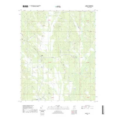
2018 Map of Marietta
USGS Topo · Published 2018About this map
Marietta and its neighbor East Marietta anchor the southern edge of this Prentiss County survey, where the landscape is defined by the winding paths of Big Brown Cr and Hurricane Cr. The distribution of rural landmarks suggests a community centered around family and faith, with numerous burial grounds such as Candler Chapel Cem, Blythes Chapel Cem, and Siloam Cem scattered among the hills and creek bottoms. The road network, largely comprised of county routes like Walden Rd, connects small crossroads and landings like Hobo Station and New Site. To the north and east, the terrain is carved by smaller tributaries including Sapling Cr and Little Jersey Cr, creating a complex drainage pattern that has historically influenced the placement of homesteads and local churches, including Mount Pisgah Cem and Mount Nebo Cem on the higher ground between the various branches of the river system.
Find a feature on this map
97 named features on this map. Tap any name to fly to it.
Don’t see what you’re looking for? This feature index may not catch every label — zoom into the map to look around manually.
Map Details
Editions of this 2018 Marietta Map
This is the sole edition of this map. No revisions or reprints were ever made.
Other maps of this area

1921 · Booneville
USGS Topo · 1:48,000

1921 · Tupelo
USGS Topo · 1:48,000

1922 · Booneville
USGS Topo · 1:62,500

1923 · Tupelo
USGS Topo · 1:62,500

1935 · Holcut
USGS Topo · 1:24,000

1950 · Paden
USGS Topo · 1:24,000

1950 · Altitude
USGS Topo · 1:24,000

1956 · Tupelo
USGS Topo · 1:250,000

1958 · Tupelo
USGS Topo · 1:250,000
1965 · Paden SE
USGS Topo · 1:24,000