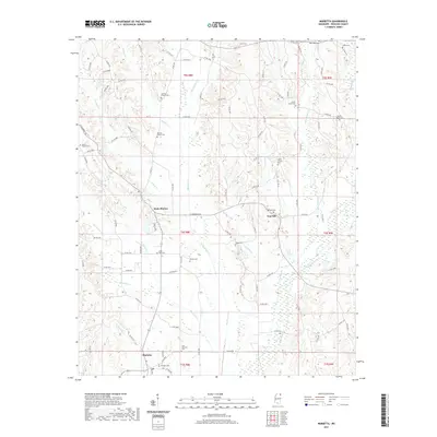
2021 Map of Marietta
USGS Topo · Published 2021About this map
Marietta anchors the southern portion of this Prentiss County landscape, where the headwaters of numerous creeks begin their descent through the local topography. The area is defined by a dense network of country roads and significant genealogical landmarks, including a high concentration of cemeteries such as Blythes Chapel Cem, Candler Chapel Cem, and Zions Rest Cem. These small burial grounds are often associated with early settlement clusters like Hobo Station and New Site. The natural drainage of the region is driven by the meandering paths of Big Brown Cr, Hurricane Cr, and Sapling Cr, which create the valleys and ridges that dictate the placement of the rural road system. This modern survey provides a detailed look at the persistent rural character of northeast Mississippi, where family-named landmarks like Rhoads Cem and Massey Cem preserve the names of local inhabitants across generations.
Find a feature on this map
95 named features on this map. Tap any name to fly to it.
Don’t see what you’re looking for? This feature index may not catch every label — zoom into the map to look around manually.
Map Details
Editions of this 2021 Marietta Map
This is the sole edition of this map. No revisions or reprints were ever made.
Other maps of this area

1921 · Booneville
USGS Topo · 1:48,000

1921 · Tupelo
USGS Topo · 1:48,000

1922 · Booneville
USGS Topo · 1:62,500

1923 · Tupelo
USGS Topo · 1:62,500

1935 · Holcut
USGS Topo · 1:24,000

1950 · Paden
USGS Topo · 1:24,000

1950 · Altitude
USGS Topo · 1:24,000

1956 · Tupelo
USGS Topo · 1:250,000

1958 · Tupelo
USGS Topo · 1:250,000
1965 · Paden SE
USGS Topo · 1:24,000