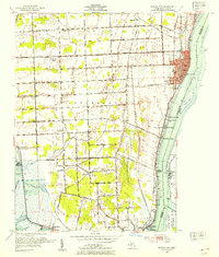
1952 Map of Marine City
USGS Topo · Published 1954About this map
The St Clair River corridor in the early 1950s was a landscape defined by its international border and bustling shoreline settlements. This survey captures the riverine economy between Marine City and Algonac, where the Chesapeake and Ohio and Port Huron and Detroit railroads trace the Michigan bank. The map reveals a dense network of country schools like Diem Sch and Maple Crest Sch and communal landmarks such as Gleaners Hall. Along the water, recreational and residential pockets like Avalon Beach and Cherry Beach appear alongside the industrial footprint of the river. Across the water on the Canadian side, the Walpole Island Indian Reserve and Woodtick Island sit in the main channel, illustrating the close proximity of Ontario hamlets like Port Lambton and Baby Point to their American neighbors.
Find a feature on this map
63 named features on this map. Tap any name to fly to it.
Don’t see what you’re looking for? This feature index may not catch every label — zoom into the map to look around manually.
Map Details
Editions of this 1952 Marine City Map
2 editions found
Other maps of this area

1912 · Port Huron
USGS Topo · 1:62,500

1914 · Algonac
USGS Topo · 1:62,500

1928 · Hicky
USGS Topo · 1:62,500

1929 · Port Huron
USGS Topo · 1:62,500

1936 · St. Clair
USGS Topo · 1:31,680

1936 · Rattle Run
USGS Topo · 1:31,680

1936 · New Baltimore
USGS Topo · 1:31,680

1936 · Algonac
USGS Topo · 1:31,680

1939 · New Baltimore
USGS Topo · 1:24,000

1939 · Adair
USGS Topo · 1:24,000