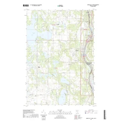
2019 Map of Marine on St. Croix
USGS Topo · Published 2019About this map
Marine on St. Croix and the surrounding Washington County landscape are defined by a complex network of glacial lakes and the steep valley of the St. Croix River. The settlement patterns in this area show a clear division between the riverfront heritage of Copas and Otisville and the agricultural upland around Scandia. Transportation infrastructure is dominated by the Minnesota Wisconsin railroad line following the river's edge, while the interior is marked by numerous water bodies including Big Marine Lake, Square Lake, and Big Carnelian Lake. Local history is preserved at sites like Elim Cem and Oakland Cem, which serve as anchors for genealogists. The eastern boundary is shaped by the St. Croix Wild and Scenic River, where the state line meets Greenburg Island. In the south, the presence of Keller Airport signifies the area's continued role as a gateway between the Twin Cities and the river valley.
Find a feature on this map
114 named features on this map. Tap any name to fly to it.
Don’t see what you’re looking for? This feature index may not catch every label — zoom into the map to look around manually.
Map Details
Editions of this 2019 Marine on St. Croix Map
This is the sole edition of this map. No revisions or reprints were ever made.
Other maps of this area

1900 · St Croix Dalles
USGS Topo · 1:62,500

1901 · St Croix Dalles
USGS Topo · 1:62,500

1948 · New Richmond
USGS Topo · 1:62,500

1948 · Stillwater
USGS Topo · 1:62,500

1949 · New Richmond
USGS Topo · 1:62,500

1949 · Stillwater
USGS Topo · 1:62,500

1951 · White Bear Lake East
USGS Topo · 1:24,000

1951 · Stillwater
USGS Topo · 1:24,000

1953 · Stillwater
USGS Topo · 1:250,000

1954 · Hugo
USGS Topo · 1:24,000