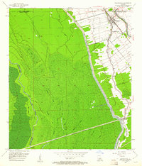
1953 Map of Maringouin
USGS Topo · Published 1961About this map
The Atchafalaya Floodway dominates the western half of this landscape, its expansive bottomlands crisscrossed by waterways like Bayou Burron and East Fork Bayou des Glaises. This engineering feat is bounded by the East Protection Levee, which separates the swampy interior from the agricultural and residential corridors to the east. Along the winding Bayou Maringouin, small communities and church-centered settlements define the local culture. The town of Maringouin serves as a focal point near the northern border, where the Texas and Pacific Railroad and regional roads intersect. Genealogists will find significant local history markers such as the St Peter Cem and several community institutions including the Upper Maringouin Sch and Little Zion Ch. The transition from the dense, flooded timber of Tight Island to the cleared fields near Musson illustrates the human adaptation to this deltaic environment during the mid-20th century.
Find a feature on this map
32 named features on this map. Tap any name to fly to it.
Don’t see what you’re looking for? This feature index may not catch every label — zoom into the map to look around manually.
Map Details
Editions of this 1953 Maringouin Map
2 editions found
Other maps of this area

1906 · Bayou Sara
USGS Topo · 1:125,000

1935 · Osca Bayou
USGS Topo · 1:62,500

1939 · Fordoche
USGS Topo · 1:62,500

1940 · Grosse Tete
USGS Topo · 1:62,500

1953 · Cow Bayou
USGS Topo · 1:24,000

1953 · Maringouin
USGS Topo · 1:24,000

1953 · Grosse Tete SW
USGS Topo · 1:24,000

1954 · Fordoche
USGS Topo · 1:24,000

1954 · Erwinville
USGS Topo · 1:24,000

1954 · Grosse Tete
USGS Topo · 1:24,000